 Pura Osa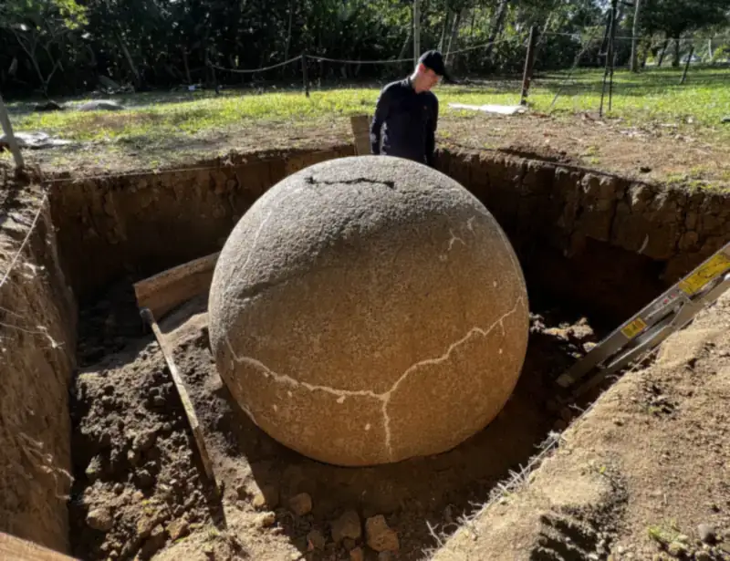
In short
- Before 1500: chiefdoms of the Diquís delta carve the stone spheres now recognized by UNESCO.
- 1914 and 1940: Osa is created as a canton, then split in two to reach roughly its current shape.
- 1938–1984: the banana company dominates Palmar and the southern lowlands, and thousands of newcomers arrive.
- 1975: Corcovado National Park is decreed; in the mid-1980s the last big gold rush ends with the evictions of 1986.
Timeline
| Year | What happened |
|---|---|
| c. 500–1500 | Chiefdoms of the Diquís delta carve their stone spheres. Finca 6 preserves some of them where they were placed. |
| Early 1520s | Spanish expeditions reach the Pacific south. Tradition says the explorer Gil González Dávila met a chief named Osa. |
| 1914 | Law 31 (June 26) creates the canton of Osa, much larger than today, with its seat in Buenos Aires. |
| 1923 | The state lets Costa Ricans claim parcels of up to 50 hectares of unclaimed land. A report that year estimates that about eight in ten residents come from Chiriquí, in Panama. |
| 1929 | A second mayoralty is opened in Puerto Jiménez because of the distances and poor communication. |
| 1930s | Gold-bearing sands are reported and artisan miners start working the rivers. |
| 1938 | The banana company settles in Palmar Sur and moves its operations to the Pacific south. Stone spheres begin to be uncovered in the cleared delta. |
| 1940 | Law 185 (July 29) separates Buenos Aires from Osa. Law 227 (August 13) makes Puerto Cortés the seat of Osa. |
| c. 1957 | The Inter-American Highway reaches the area and farming villages grow along it. Puerto Cortés becomes a city. |
| 1960s–70s | Gold attracts families and small mining companies. Plans for large-scale logging on the peninsula alarm scientists. |
| 1975 | President Daniel Oduber decrees Corcovado National Park in October. |
| 1983–1986 | A gold rush brings many miners into Corcovado. They are evicted in 1986. |
| 1984 | After a strike, the banana company abandons banana growing in the region. |
| 2014 | UNESCO inscribes the stone-sphere sites of the Diquís. Guides become mandatory in Corcovado. |
Dates and laws were compared with historical studies from the Universidad de Costa Rica and with the decrees themselves. Where the record is a tradition rather than a document, we say so.
The first peoples and the stone spheres
Long before any map carried the word Osa, the floodplain of the Térraba River was home to chiefdoms with ranked leaders, craftsmen and large villages. Between roughly 500 and 1500 CE they farmed, traded and carved almost perfectly round spheres from hard volcanic rock. Today the Boruca and Térraba peoples, whose territories lie just inland in the neighboring canton of Buenos Aires, keep their ceremonies and crafts alive. The story of the spheres has its own page: Finca 6 and the stone spheres.
Where the name comes from
According to the traditional account, the explorer Gil González Dávila met a local chief named Osa in the early 1520s, and the name stuck to the region. It is repeated in many local histories, but it comes from colonial-era accounts, so we present it as tradition. What is certain is that the far south stayed lightly populated for a very long time: few people lived here beyond Indigenous communities and a handful of settlers.
A canton is born, and then split
On June 26, 1914, Law 31 created the canton of Osa. It was far bigger than today’s Osa and its seat was in Buenos Aires. Distances were so great that in 1929 a second mayoralty was opened in Puerto Jiménez, and as early as 1915 the people of El Pozo (today’s Puerto Cortés area) asked to move the seat closer to them. They had to wait: on July 29, 1940, Law 185 separated Buenos Aires from Osa, and Law 227 set Puerto Cortés as the seat of the new, smaller Osa. Puerto Cortés became a city in 1957. Today the canton has six districts: Puerto Cortés, Palmar, Sierpe, Bahía Ballena, Piedras Blancas and Bahía Drake.
Settlers from near and far
In 1923 the state allowed Costa Ricans over 18 to claim up to 50 hectares of unclaimed land, and requests arrived by the dozens, especially for Drake and El Pozo. A report that year estimated that about eight in ten residents of the canton came from Chiriquí, in neighboring Panama. The south was not an empty frontier waiting for outsiders; it was a place where families from several regions built farms, trails and villages with very little help from the state.
The banana years (1938–1984)
As disease hit its Caribbean farms, the United Fruit Company’s Costa Rican subsidiary looked to the Pacific south, and the government, eager to populate and open the region, signed banana contracts with it. By 1938 the company had settled in Palmar Sur and began clearing the Diquís delta; it would later run the port of Golfito. Workers came from all over: in 1950 the canton had about 11,500 inhabitants and roughly eight in ten were newcomers, with Palmar alone near 7,700. Around 1957 the Inter-American Highway arrived and farming villages grew along it. The company also uncovered, moved and broke many stone spheres. In 1984, after a strike, it abandoned banana growing in the region, and the economy turned to other crops, services and, little by little, tourism.
Gold and the oreros
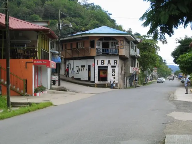
Reports of gold-bearing sands go back to the mid-1930s. For decades the oreros, artisan miners who panned the rivers of the peninsula, lived deep in the forest, and in the 1960s and 1970s small companies and whole families depended on gold. Between 1983 and 1985 the last big rush brought many miners into what is now Corcovado (estimates range from about a thousand to several thousand), and they were evicted in 1986. Mercury and sediment from that period damaged rivers, and small-scale illegal mining has never fully disappeared. Many former miners and hunters later became guides, rangers and conservation workers, which is one of the quieter success stories of Osa.
1975: the park that changed the map
Scientists and conservationists warned that logging plans and mining were destroying one of the richest forests in Central America. In October 1975 President Daniel Oduber decreed Corcovado National Park. Creating it meant buying out landholders and miners, and the memory of those years still shapes how some local families see the park. It is also why today’s rules, such as mandatory certified guides since 2014, matter so much: they protect the forest and keep a share of the income in local hands.
Read more: Corcovado National Park · Corcovado sectors compared.
From taking to caring
The same land that once gave bananas, timber and gold now lives from nature, culture and visitors. In 2014 UNESCO recognized the stone-sphere sites, whales draw people to Uvita every year and small lodges, guides and boat captains from the communities carry much of the work. Many of Osa’s best stories are still told by families who lived the banana years, the gold years or the first years of the park. That is the heart of what we call regenerative travel: leaving more in the place than you take. Regenerative travel in Osa · The origin seal · Support Osa · About.
Where to see this history today
| Place | What you will find |
|---|---|
| Finca 6, Palmar Sur | Spheres still in their original lines and a museum about the chiefdoms. |
| Golfito | The old banana port: wooden buildings, the waterfront and the duty-free warehouse. |
| Puerto Jiménez | The peninsula’s main town, shaped by gold, farming and now Corcovado visitors. |
| Corcovado | Forest that was once mined and logged, now one of the most protected places in the country. |
| Dos Brazos de Río Tigre | An old gold-mining community near one of the park entrances (see the map). |
| Boruca and Térraba | Indigenous territories in the neighboring canton; the Diablitos ceremony tells the story of resistance. |
Next: Festivals and events in Osa, month by month.
Frequently asked questions
Why is it called Osa?
According to the traditional account, the explorer Gil González Dávila met a local chief named Osa in the early 1520s, and the name stayed with the region. It comes from colonial-era accounts repeated in local histories, so we treat it as tradition rather than a fully documented fact.
When did Osa become a canton?
Osa first appeared as a canton on June 26, 1914 (Law 31), a much larger one with Buenos Aires as its seat. On July 29, 1940, Law 185 separated Buenos Aires, and Osa kept the smaller territory it has today, with Puerto Cortés as its seat.
Who lived in Osa before the Spanish arrived?
Chiefdoms of the Diquís delta, which flourished from about 500 to 1500 CE. They farmed, traded and carved the famous stone spheres. Indigenous communities such as the Boruca and Térraba, in the neighboring canton of Buenos Aires, keep their traditions alive today.
Was there a gold rush in Osa?
Yes. Gold-bearing sands were reported in the 1930s and artisan miners, the oreros, worked the rivers for decades. Between 1983 and 1985 a large rush brought many miners into what is now Corcovado, and they were evicted in 1986. Small-scale illegal mining has never fully disappeared.
When was Corcovado National Park created?
In October 1975, by decree of President Daniel Oduber, after scientists and conservationists warned about logging and mining on the peninsula. Creating the park meant buying out landholders and miners, which is part of why the topic is still sensitive for some local families.
When did the banana company leave the south?
After a strike, the company abandoned banana growing in the region around 1984, almost half a century after it settled in Palmar Sur in 1938.
Some links on this page are affiliate links. If you book through them, Pura Osa may earn a small commission at no extra cost to you. Recommendations are not paid. Prices, hours and schedules change; always confirm locally.